Kepler Track from Te Anau: huts, the alpine day and the seasons
The 60 km Kepler Track loop from Te Anau: stage times, hut and camping plans, Great Walk fees and bookings, the alpine section, winter conditions and side trips.
Sources checked - 27 October 2026
In this article
The Kepler Track is a 60 km loop that starts and ends on the edge of Te Anau, climbs out of beech forest onto the tussock ridges of the Kepler Mountains, and comes back along the Iris Burn valley and Lake Manapouri. Most people walk it in 4 days and 3 nights, staying at Luxmore, Iris Burn and Moturau huts (DOC). In the 2026/27 Great Walks season, from 27 October 2026 to 30 April 2027, every hut and campsite night must be booked in advance, and an international adult pays NZD 132 per hut night. The crux is the 14.6 km alpine day from Luxmore Hut to Iris Burn Hut, which is exposed to strong wind and, into early summer, avalanche paths. Outside the season the same route becomes a winter alpine trip that needs ice axe, crampons and avalanche gear.
The loop in six sections
DOC divides the track like this. The times are DOC's estimates; the elevations are from DOC's walking guide (walking guide).
| Section | Distance | Time | What it is |
|---|---|---|---|
| Kepler Track car park to Brod Bay | 5.6 km | 1 hr 30 min | Flat lakeshore forest on Lake Te Anau |
| Brod Bay to Luxmore Hut (1085 m) | 8.2 km | 3 hr 30 min - 4 hr 30 min | Steady climb past limestone bluffs to the bushline, then about 45 min in the open |
| Luxmore Hut to Iris Burn Hut (497 m) | 14.6 km | 5 - 6 hr | The alpine ridge, then a zigzag descent into the Iris Burn |
| Iris Burn Hut to Moturau Hut | 16.2 km | 5 - 6 hr | Long valley walk through beech forest and a gorge |
| Moturau Hut to Rainbow Reach | 6 km | 1 hr 30 min - 2 hr | Wetland and forest to a swing bridge over the Waiau River |
| Rainbow Reach to Kepler Track car park | 9.5 km | 2 hr 30 min - 3 hr 30 min | Riverside forest back to the start |
The car park sits beside the Lake Te Anau control structure, about 5 km from town. From the Fiordland National Park Visitor Centre on the Te Anau lakefront you can walk to it in about 50 minutes on a lakeside path (DOC; walking guide). Rainbow Reach is a second road end, 12 km from Te Anau, which is why many walkers finish there by bus rather than walking the last 9.5 km. The track can be walked in either direction.
Choosing your nights
Where you sleep decides how long each day is, because the overnight options are unevenly spaced. Luxmore Hut has no campsite, and Moturau has a hut but no campsite. The two campsites, Brod Bay and Iris Burn, have 15 tent sites each, and camping is not allowed at the Forest Burn and Hanging Valley shelters on the alpine section (DOC). Adding up DOC's stage figures gives three realistic plans:
| Plan | Nights | Longest day |
|---|---|---|
| Classic, anticlockwise | Luxmore, Iris Burn, Moturau huts | 13.8 km and the main climb on day 1; 16.2 km on day 3 |
| Three days | Luxmore and Iris Burn huts, then out to Rainbow Reach | Iris Burn to Rainbow Reach, 22.2 km, about 6 hr 30 min - 8 hr |
| Camping | Brod Bay and Iris Burn campsites | Brod Bay to Iris Burn over the alpine section, 22.8 km, about 8 hr 30 min - 10 hr 30 min, then 22.2 km out |
The camping plan is cheaper but puts the whole climb and the whole ridge into one long day, which leaves little slack if you have to wait out bad weather. A mixed plan, such as Luxmore Hut followed by Iris Burn Campsite, is possible because each night is booked separately.
The usual direction is anticlockwise, Luxmore first. A Te Anau transport operator recommends it because the alpine crossing then falls on day 2, early in the day, before the afternoon weather tends to change (Fiordland Outdoors guide). Walking clockwise from Rainbow Reach gives a short first day to Moturau, but you then climb the zigzags from Iris Burn to the ridge.
The alpine day: Luxmore Hut to Iris Burn
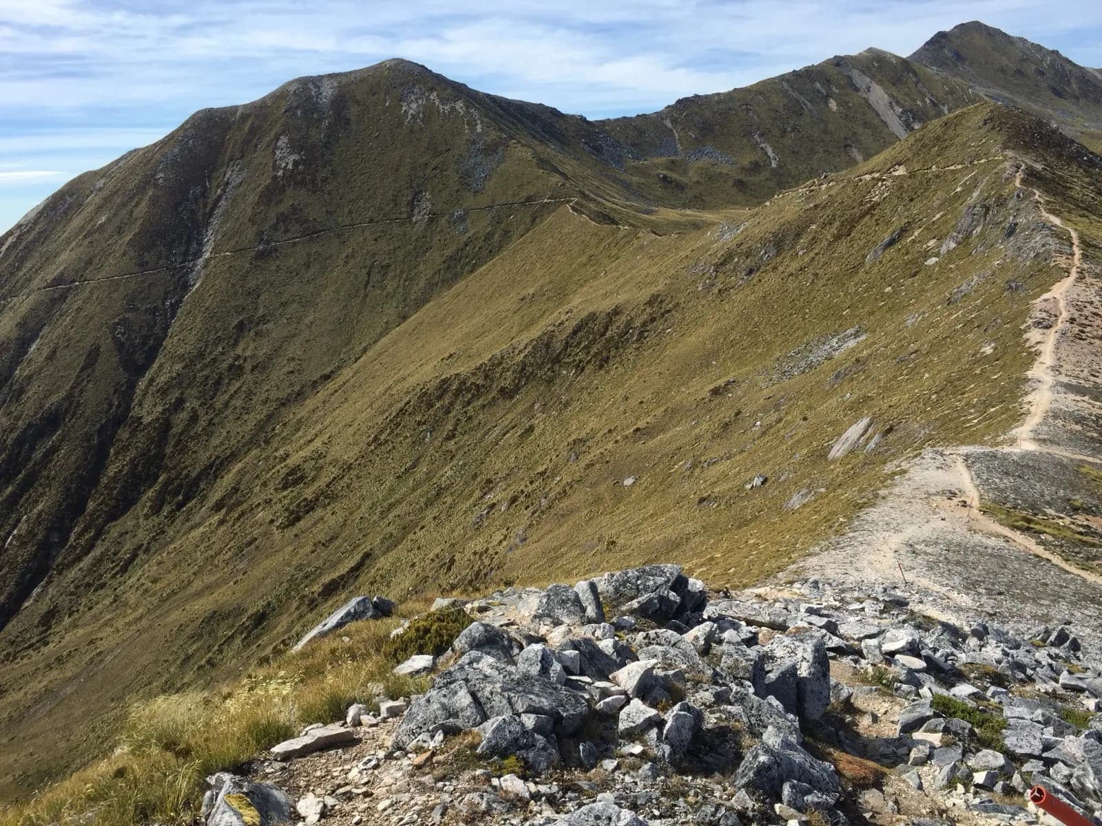
From Luxmore Hut the track climbs gradually to a ridge just below the summit of Mount Luxmore, drops to a shelter near the Forest Burn saddle, then sidles and follows the ridge for about two hours to Hanging Valley Shelter. A long open ridge leads towards the Iris Burn before a series of zigzags descends through forest to Iris Burn Hut (walking guide). The highest point on the main track is around 1,400 m near Luxmore Saddle (Wikipedia). Fill your bottles at Luxmore Hut: DOC says there is no reliable water on the alpine section until Iris Burn Hut (DOC).
Three things make this day different from the rest of the track:
- Wind. DOC warns that winds strong enough to blow walkers off their feet can occur between Luxmore Hut and the descent to the Iris Burn. In heavy rain, strong wind or wintry weather, its advice is to wait at Luxmore Hut until conditions improve (walking guide). Fiordland's rainfall can reach 9,000 mm a year and the weather can change quickly in any season (DOC).
- Avalanches. The track crosses complex avalanche terrain with nine avalanche paths, most of which can reach the track, and the risk can extend into December. During the Great Walks season DOC manages this risk and may close the section between Luxmore and Iris Burn huts (DOC). The start zones of the paths cannot be seen from the track. If walkers cannot go on, DOC's walking guide lists options that can include a refund, an extra night in a hut, changing direction or a helicopter transfer across the hazard (walking guide). The booking terms refund only the unused nights, and DOC does not rearrange transport or accommodation booked elsewhere (booking terms).
- Kea. These alpine parrots live on the ridge and around Iris Burn and will damage unattended gear (Iris Burn Hut). DOC suggests that campers worried about their tents book the hut instead (Iris Burn Campsite).
DOC does not recommend the track for children under 10 (DOC), and anyone 14 or under must be accompanied by an adult (booking terms).
Great Walk season or winter route
The track stays open all year, but it is two different trips.
27 October to 30 April. Huts have bunks with mattresses, heating, cooking benches with fuel supplied, flush toilets, cold running water and solar lighting in the kitchen, but no showers, cooking utensils or food. A ranger is based at each hut (Luxmore Hut). The tap water is untreated and DOC advises boiling it, and the bunkrooms are not heated, so bring warm clothes to sleep in (DOC). Luxmore has 54 bunks, Iris Burn 50 and Moturau 40 (Iris Burn Hut; Moturau Hut). Campers cannot use hut facilities and need their own stove (Brod Bay Campsite).
1 May to 26 October. The track is not kept to Great Walk standard. Gas is removed, toilets become pit toilets, indoor water is turned off and there are no rangers. The alpine section is unmarked and often under thick snow, and DOC does not manage avalanche risk (DOC; winter tramping). DOC lists the extra equipment you will need: food for at least two extra days, stove and gas, ice axe, crampons, avalanche transceiver, shovel and probe, and a personal locator beacon. It expects navigation and alpine skills, a check of the backcountry avalanche advisory, and a call to the Te Anau visitor centre before you leave. Transport runs only with minimum numbers and not always daily, so it must be arranged in advance.
The shoulder weeks need the most thought. Late October and November are inside the booking season, yet the avalanche risk on the ridge can last into December. On 27 October 2026, the first day of the season, the New Zealand Avalanche Advisory rated the danger in Fiordland as Considerable above 1,200 m after 300 to 500 mm of rain on the snowpack (NZ Avalanche Advisory). The same day DOC's alert for the track reported that a 12 m bridge had washed out near Rocky Point, between Iris Burn and Moturau huts, and warned against crossing any stream in flood (DOC). The regional advisory covers the backcountry in general, while DOC manages the track's own avalanche risk in season, so check both DOC's track alerts and the advisory shortly before you start.
Booking and what it costs
Great Walks season fees, in NZD per person per night (DOC; Great Walks pricing):
| Hut, NZ resident | Hut, international | Campsite, NZ resident | Campsite, international | |
|---|---|---|---|---|
| Adult (18+) | 88 | 132 | 28 | 42 |
| Child (5-17) | 44 | 66 | 14 | 21 |
| Infant (0-4) | Free | 66 | Free | 21 |
Only New Zealand infants stay free: DOC's international child rate covers ages 0 to 17, and every person in the party, infants included, needs a booking (booking terms). For the classic three hut nights that is NZD 396 for an international adult and NZD 264 for a New Zealand resident; two campsite nights cost NZD 84 or NZD 56. The resident rate needs proof such as a passport or New Zealand driver's licence; a party that cannot show it owes the difference plus a NZD 50 administration fee per person (booking terms).
Book online through DOC. Bookings for 2026/27 opened on 19 May 2026 at 9:30 am through a virtual queue, and Kepler huts ran at 91 per cent occupancy the previous summer, close behind the Milford and Abel Tasman huts at about 95 per cent. DOC added that many campsites still had good availability while huts were full (DOC media release), so if the huts are gone for your dates, the camping or mixed plan above is the realistic fallback. Points from the booking terms that matter here (booking terms):
- Staying without a valid booking costs the normal fee plus the full adult fee, for example NZD 264 for an international adult at a hut.
- A booking cannot be moved to a different hut or campsite.
- If DOC closes the track, you can ask within seven days for a refund of the unused nights or a date transfer. Weather closures are not refunded automatically.
- Once 48 hours have passed since booking, cancelling costs 10 per cent of the fee up to 15 days before arrival, 50 per cent from 14 days, 75 per cent from 3 days and 100 per cent from the day before arrival.
In the off-season only Luxmore Hut must be booked, at NZD 35 per adult, and a Backcountry Hut Pass can pay for it but Hut Tickets cannot. Iris Burn and Moturau cost NZD 30 and are first come, first served, as are the Brod Bay and Iris Burn campsites at NZD 10. At the unbooked huts you pay with Backcountry Hut Tickets, bought from a DOC visitor centre before you go, or a Backcountry Hut Pass (DOC).
The track is busiest around the Kepler Challenge, a mountain race over the loop held on the first Saturday of December, 5 December in 2026 (DOC).
Getting to the start and back
DOC says shuttle buses run daily in the Great Walks season and a scheduled boat goes to Brod Bay (DOC). One operator lists a water taxi from the Te Anau lakefront to Brod Bay at 8:30, 9:30 and 10:30 am and 2:30 pm, with an extra 8 am boat from mid-November to the end of March, at NZD 30 per adult one way, and buses from Rainbow Reach to Te Anau at 10:30 am, 3 pm and 4 pm (Fiordland Outdoors). The crossing takes about 15 minutes and removes the first 5.6 km, so Luxmore Hut is a single climb of 3.5 to 4.5 hours from the boat. Commercial timetables and fares change; confirm them when you book.
If you have a car, you can leave it at the control structure car park and walk the whole loop back to it. Otherwise the walk from the visitor centre adds about 50 minutes each way.
Side trips and short walks
- Luxmore Cave, 20 minutes return from Luxmore Hut. DOC asks you to write your plan in the hut book and to carry at least two light sources each (walking guide). The side track can be icy in winter.
- Mount Luxmore summit, 1,472 m, 30 minutes return from a signposted turn-off on the way to Iris Burn (DOC). It is the highest point you can reach on the walk and is best left for clear weather.
- Iris Burn Waterfall, about 40 minutes return from Iris Burn Hut, with a pool for a cold swim. Look out for blue duck (whio) (walking guide).
- Day walks without a booking. From the car park, Dock Bay and Brod Bay make an easy lakeshore walk. Luxmore Hut is about 5 to 6 hours from the car park, so as a return day walk it is a long day unless you take the boat to Brod Bay. Moturau Hut is about 2 hours from Rainbow Reach (Moturau Hut).
Lakes, wildlife and didymo
Moturau Hut sits in a clearing beside a beach on Lake Manapouri, good for a swim or a paddle (Moturau Hut). The invasive alga didymo is present in Lake Te Anau, Lake Manapouri and the Waiau River, but according to DOC not in the Iris Burn. DOC asks walkers not to take water from the lakes and the Waiau, not to fill bottles there, and not to swim in the rivers after swimming in the lakes; anything that has touched lake water should be checked, cleaned and dried before it goes into another stream (DOC; Iris Burn Hut). In the Iris Burn valley, listen at night for Fiordland kiwi (tokoeka) and watch at dusk for long-tailed bats, a colony of which was found in the valley in 2011 (walking guide). Heavy rain can flood the valley's side streams; DOC's advice is not to cross a stream in flood and to wait on higher ground for the level to drop.
The track opened in February 1988 as a project for the centenary of New Zealand's national parks, partly to take pressure off the Milford and Routeburn tracks. It takes its name from the Kepler Mountains, which the surveyor James McKerrow named after the astronomer Johannes Kepler (Wikipedia).
Fees, booking rules, season dates, hut facilities, track alerts and warnings were checked against DOC pages and documents, and the avalanche rating against the New Zealand Avalanche Advisory, on 27 October 2026; transport times are from one operator's website on the same date. This is a source check, not a walk of the track.
Sources & further reading
- Kepler Track - Department of Conservation
- Kepler Track walking guide (summer) - Department of Conservation
- Kepler Track winter tramping - Department of Conservation
- Luxmore Hut - Department of Conservation
- Iris Burn Hut - Department of Conservation
- Moturau Hut - Department of Conservation
- Brod Bay Campsite - Department of Conservation
- Iris Burn Campsite - Department of Conservation
- Huts, campsites, Great Walks, cabins and lodges terms and conditions - Department of Conservation
- Great Walks pricing - Department of Conservation
- Ready, set, naturing: DOC Great Walk hut and campsite bookings open from 12 May - Department of Conservation
- Fiordland avalanche forecast - New Zealand Avalanche Advisory (NZ Mountain Safety Council)
- Kepler Track transport - Fiordland Outdoors
- Your guide to the Kepler Track - Fiordland Outdoors
- Kepler Track - Wikipedia
Tags
- Kepler Track
- Great Walks
- Te Anau
- Luxmore Hut
- Iris Burn
- Moturau
- Fiordland National Park
- New Zealand