Heaphy Track: direction, huts, transport and the bike season
Plan the 78.4 km Heaphy Track: which end to start, huts and campsites, fees, transport between Golden Bay and Karamea, the May-November bike season, floods and tides.
Sources checked - 27 October 2026
In this article
The Heaphy Track is the longest Great Walk: 78.4 km one way across Kahurangi National Park, from Brown Hut at the head of the Aorere Valley in Golden Bay to Kohaihai, north of Karamea on the West Coast. Walkers take 4 to 6 days; riders take 2 to 3 days on a Grade 4 mountain bike track, which is open to bikes only from 1 May to 30 November (DOC). It is a well-formed track whose highest point is only 915 m, but it is not a loop, so the real planning problems are getting back to your car or your town, booking huts (required every night of the year), and allowing for floods and high tides on the West Coast end.
Which end to start from
The track can be walked or ridden in either direction (walking guide). The difference is where the climbing falls. DOC's elevation profile shows one long ascent from Brown Hut to Perry Saddle, a gently undulating middle across the Gouland and Mackay Downs at roughly 600 to 900 m, a long descent from James Mackay Hut to the Heaphy River, and a flat coastal finish (elevation profile).
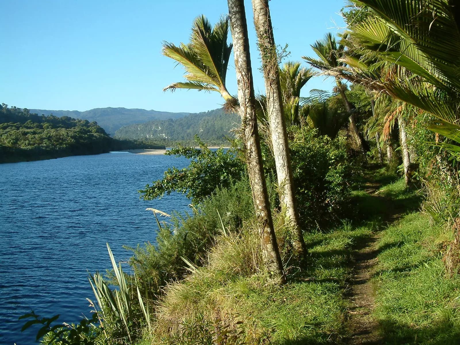
- From Brown Hut (east to west). The most popular direction, according to a Golden Bay transport operator (Golden Bay Air FAQ). Most of the climbing is done on day 1, a 17.5 km, five-hour walk up a graded old road survey line to Perry Saddle Hut at 880 m. Thirty minutes before the hut, a short side track leads to the Flanagans Corner viewpoint, at 915 m the highest point of the track (DOC). The trip then ends on the coast among nikau palms.
- From Kohaihai (west to east). The first day follows the coast with the heaviest pack, and the climb comes on the second day, up from the Heaphy River to James Mackay Hut, which stands about 750 m above the river mouth. Starting on the West Coast also lets you time the coastal section for the tide on day 1.
For riders the descent from James Mackay Hut to Lewis Shelter is the technical part, with tight corners, slippery rock and steep drops beside the track (DOC), so the direction mainly changes whether you ride it up or down.
Huts and campsites from end to end
There are six huts and nine Great Walk campsites, and all must be booked in advance all year (DOC). Distances are cumulative from Brown Hut, taken from DOC's stage figures; Lewis Shelter is split using the walking guide (walking guide).
| Stop | From Brown Hut | Hut bunks | Gas cooking | Tent sites |
|---|---|---|---|---|
| Brown Hut | 0 km | 16 | No | 10 |
| Aorere Shelter | about 4 hr | none | - | 4 |
| Perry Saddle Hut | 17.5 km | 28 | Yes | 5 |
| Gouland Downs Hut | 24.5 km | 8 | No | 5 |
| Saxon Hut | 29.9 km | 16 | Yes | 5 |
| James Mackay Hut | 41.7 km | 28 | Yes | 4-5 |
| Lewis Shelter | about 54 km | emergency only | - | - |
| Heaphy Hut | 62.2 km | 32 | Yes | 20 |
| Katipo Creek Shelter | 2 hr 30 min past Heaphy Hut | none | - | 5 |
| Scotts Beach | 45 min before Kohaihai | none | - | 9 |
| Kohaihai road end | 78.4 km | none | - | 50 (standard campsite) |
Bunk and site numbers and the cooking facilities come from each hut and campsite page (Brown Hut; Perry Saddle Hut; Gouland Downs Hut; Saxon Hut; James Mackay Hut; Heaphy Hut). DOC's James Mackay campsite page gives both 4 and 5 sites.
Every hut has heating, toilets with paper and cold running water, and mattresses, but you bring your own sleeping bag and cooking utensils; there are no showers. At Brown Hut and Gouland Downs Hut there is no gas and no lighting, so carry a stove if you plan to stay there; Saxon Hut has gas but no lighting. James Mackay Hut (opened in October 2014) and Heaphy Hut have separate bunk rooms and flush toilets. Hut rangers move between huts in summer, checking bookings and giving weather and track information. All campsites have tap water and toilets; Scotts Beach's water can be limited in summer, and campers cannot use the hut facilities (Scotts Beach Campsite; DOC).
Brown Hut is a five-minute walk from the Golden Bay road end, which makes it a useful first night if you arrive late, or a refuge if the fords on the road out are flooded (Brown Hut). Gouland Downs Hut is small and close to Perry Saddle, so it suits a short day rather than a main stop.
Building the days
Two hut plans cover most walkers:
| Plan | Nights | Daily distances |
|---|---|---|
| 4 days | Perry Saddle, James Mackay, Heaphy | 17.5, 24.2, 20.5, 16.2 km |
| 5 days | Perry Saddle, Saxon, James Mackay, Heaphy | 17.5, 12.4, 11.8, 20.5, 16.2 km |
The 4-day plan is the common one, and the transport operator suggests the 5-day version for less experienced trampers (Golden Bay Air FAQ). The figures are DOC's stage distances added together (DOC). In both plans the 20.5 km day between James Mackay and Heaphy huts, about six hours, runs through the lower Heaphy valley, where the track floods in heavy rain, so it should not be the day you have to rush.
Campers have more flexibility because of the extra campsites at Aorere Shelter, Katipo Creek Shelter and Scotts Beach, but tent numbers are small: six of the nine campsites have four or five sites.
Fees and booking
Prices are per person per night, in NZD. The summer rate runs from 1 October to 30 April, and international visitors pay more only in that period (DOC).
| Period | Hut, adult NZ / international | Hut, child NZ / international | Campsite, adult NZ / international |
|---|---|---|---|
| 1 Oct - 30 Apr | 44 / 66 | 22 / 33 | 19 / 28 |
| 1 May - 30 Jun | 38 / 38 | 19 / 19 | 19 / 19 |
| 1 Jul - 31 Aug | 30 / 30 | 15 / 15 | 19 / 19 |
| 1 - 30 Sep | 38 / 38 | 19 / 19 | 19 / 19 |
New Zealand children under 5 stay free, but DOC's international child rate covers ages 0 to 17, so an international infant pays the child rate. The New Zealand rate needs proof of residency, and Backcountry Hut Passes, Hut Tickets and the DOC Campsite Pass are not accepted on the track (DOC; Brown Hut). Three summer hut nights cost an international adult NZD 198 and a New Zealand adult NZD 132; the same three nights in July cost NZD 90 for anyone. Kohaihai Campsite at the road end is a separate standard campsite at NZD 10 per adult (Kohaihai Campsite).
Bookings for stays from 1 July 2026 to 30 June 2027 opened on 20 May 2026. DOC describes the Heaphy as a track that often still has space, after strong growth in bookings as walkers returned following storm repairs (DOC media release). Under DOC's booking terms, staying without a valid booking is charged at the normal fee plus the full adult fee, and a booking cannot be moved to a different hut or campsite (booking terms). Because the huts and the transport both have limited space, check that both are available for your dates before paying for either; Golden Bay Air's own pages give that advice in both orders (Golden Bay Air; Golden Bay Air FAQ).
Getting to both ends
The two road ends are far apart by road: Brown Hut is 156 km from Nelson (about 2 hr 25 min, via Collingwood and 28 km up the Aorere Valley), and Kohaihai is 110 km from Westport (about 1 hr 45 min, via Karamea and 15 km north) (DOC). A transport operator puts the road distance between the two ends at 450 km (Golden Bay Air). The usual ways round it, all listed by DOC:
- Fly back. Local operators fly into Takaka in Golden Bay and Karamea on the West Coast; Air New Zealand serves Nelson and Sounds Air serves Westport (DOC). Golden Bay Air runs scheduled flights and shuttles to both ends and offers discounted Takaka - Karamea flights from November to April; some services need a minimum number of passengers (Golden Bay Air FAQ).
- Shuttle. Buses and taxis reach both ends, and regular buses link Nelson and Westport. Karamea Express runs a regular Kohaihai shuttle from November to April and on demand outside it (Karamea Express).
- Vehicle relocation. Relocation services drive your car round to the other end.
DOC warns that some transport businesses do not operate in winter, which matters for May-to-November riders (DOC). Mobile coverage exists at both road ends, and the landlines at Brown Hut and Kohaihai have been removed, so arrange pickups before you leave signal.
The mountain bike season
Bikes are allowed only from 1 May to 30 November, and walkers share the track during that time (DOC). DOC's rules:
- Grade 4 (advanced). Fit, experienced riders plan for two full days with one night in a hut or campsite; less experienced riders should allow three days and two nights.
- Ride only from half an hour before sunrise to half an hour after sunset, to protect the nocturnal Powelliphanta snails and great spotted kiwi.
- Groups of up to six riders. No e-bikes. Bikers give way to walkers.
- No bikes in huts, shelters or on hut porches; bike stands are provided at Perry Saddle, Gouland Downs, Saxon, James Mackay and Heaphy huts. No helicopter transport of bikes in or out of the park.
- At James Mackay Hut, kea have taken to bike seats and hydraulic brake lines: remove the seat and keep it with you, and cover the lines.
- DOC may close the track to bikes after storms, heavy rain, snow or high-tide events.
Riders need the same hut or campsite bookings as walkers. October and November are the overlap: the summer hut rates already apply from 1 October while bikes are still allowed until the end of November, so those weeks bring both walkers and riders.
Floods, tides and other hazards
Rainfall averages over 4,000 mm a year and can arrive heavily with little warning; snow and strong wind are possible on the exposed tops. Winter storms can damage the track, and landslides and rock falls can happen during and after rain; DOC marks damaged sections and suggests checking with the Nelson visitor centre before you go (DOC). Three places need specific plans:
- Mackay Downs. A 70 m section across a wetland and a bridge, between Saxon and James Mackay huts, becomes impassable and dangerous in extremely wet conditions. Wait for the water to go down.
- Lewis Shelter to Heaphy Hut. Large floods occur in the lower Heaphy valley, especially in heavy rain around high tide, and DOC says it is not safe to continue when the track is flooded; wait at Lewis Shelter or Heaphy Hut. DOC's bike guidance says flooding here and on the Saxon-James Mackay section can reach 1.5 m over the track. Lewis Shelter is for emergencies, not overnight stays.
- The coast between Heaphy Hut and Kohaihai. Large waves can wash over parts of the track at high tide in rough seas, and there is no alternative route. For tide times on this coast, DOC says to subtract 30 minutes from the LINZ tide tables for Westport (tide tables). The walking guide adds that you should be ready to wait up to two hours for the tide to drop, and that tide tables are posted in Heaphy Hut and Kohaihai Shelter (walking guide). Crayfish Point now has a high-level track, but Crayfish Stream rises quickly in rain, and some small coastal streams are unbridged.
Do not swim at the Heaphy River mouth or the Kohaihai River mouth, where currents and rips are strong. If you feel a long or strong earthquake on the coast, go to higher ground straight away. Treat drinking water because of a small giardia risk, and watch for stinging nettle on the coastal section (DOC). DOC finished a predator control operation with 1080 bait in the Heaphy lowlands on 17 October 2026; the track is open, but green bait pellets and poisoned carcasses may be present, so do not touch them, and DOC says it is not safe to hunt for food there for up to eight months (DOC alert).
Wildlife and history along the way
Kahurangi is a stronghold of the great spotted kiwi (roroa). Predator control in the Heaphy valley has raised kiwi call rates, and DOC says kiwi are again resident around Heaphy Hut (DOC, 2024). Around Heaphy Hut on damp nights, look for Powelliphanta, a large carnivorous land snail (DOC). Takahē were released on Gouland Downs in 2018, but in May 2026 DOC moved birds from there to Onetahua Farewell Spit and is winding the Gouland Downs trial site down, so do not plan on seeing them on the track (DOC, 2026).
Near the Heaphy River crossing stand two large rata, which DOC calls possibly the oldest and largest in New Zealand. The river mouth is where two pounamu (greenstone) trails met, with evidence of Māori occupation going back 500 years. Saxon Hut is named after John Saxon, who surveyed the track in 1886 (DOC). Storms in February 2022 destroyed three bridges, including the Heaphy River bridge. The track fully reopened on 19 October 2023 with two new bridges, over the Heaphy and Lewis rivers; the new Heaphy bridge stands above the 100-year flood level, adjusted for climate change (DOC, 2023).
On the road from Kohaihai to Karamea, the Ōparara Arch, a 35 million-year-old limestone arch, is a 30-minute walk through forest from its car park and an easy addition after the track (DOC).
Fees, booking rules, hut facilities, bike rules, hazards and current track alerts were checked against DOC pages and documents on 27 October 2026; transport details are from operators' websites on the same date. This is a source check, not a walk of the track.
Sources & further reading
- Heaphy Track - Department of Conservation
- Heaphy Track walking guide - Department of Conservation
- Heaphy Track elevation profile - Department of Conservation
- Brown Hut - Department of Conservation
- Perry Saddle Hut - Department of Conservation
- Gouland Downs Hut - Department of Conservation
- Saxon Hut - Department of Conservation
- James Mackay Hut - Department of Conservation
- Heaphy Hut - Department of Conservation
- Heaphy Campsite - Department of Conservation
- Scotts Beach Campsite - Department of Conservation
- Kohaihai Campsite - Department of Conservation
- Heaphy Track tide tables - Department of Conservation
- Huts, campsites, Great Walks, cabins and lodges terms and conditions - Department of Conservation
- Ready, set, naturing: DOC Great Walk hut and campsite bookings open from 12 May - Department of Conservation
- Heaphy Track fully reopening tomorrow - Department of Conservation
- Kiwi sightings increase on Heaphy Track - Department of Conservation
- Takahē move into Golden Bay - Department of Conservation
- Heaphy Track FAQs - Golden Bay Air
- Heaphy Track transport for walkers - Golden Bay Air
- Karamea Express - Karamea Express
Tags
- Heaphy Track
- Great Walks
- Kahurangi National Park
- Golden Bay
- Karamea
- Kohaihai
- mountain biking
- New Zealand