Tongariro Alpine Crossing: shuttles, parking, season and alerts
Plan the Tongariro Alpine Crossing: the 4-hour parking limit and shuttles, the free booking, summer and winter seasons, the weather advisory and volcanic alert levels.
Sources checked - 27 October 2026
In this article
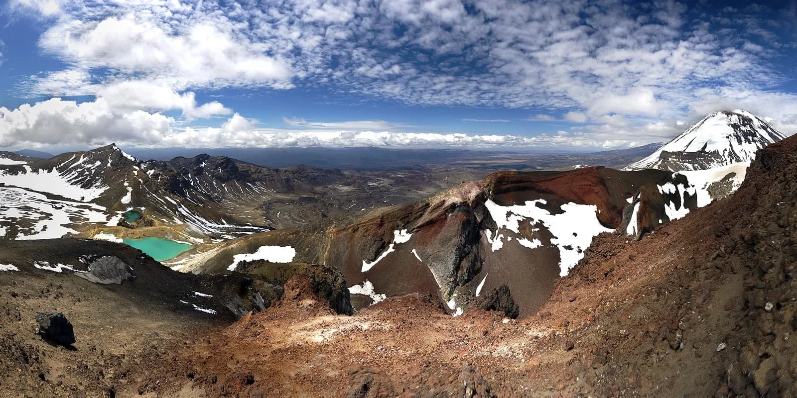
The Tongariro Alpine Crossing is a 20.2 km one-way walk across the volcanoes of Tongariro National Park, from the Mangatepōpō Road end at 1,120 m over Red Crater (1,886 m) to the Ketetahi Road end at 760 m. Allow 7 to 8 hours from November to April and 9 hours from May to October (DOC). Because it starts and ends at different roads, the logistics come down to four questions:
- Getting there: from Labour Weekend to 30 April, parking at both road ends is limited to 4 hours, which is shorter than the walk. Book a shuttle; the free DOC track booking is needed to ride one.
- Season: November to April is the walking season. From May to October the Crossing is a snow and ice route for people with alpine skills, and DOC suggests going with a guide.
- Weather: in summer DOC checks the Red Crater forecast at 6 am and posts a "Not Recommended Today" advisory when wind, cold or rain pass set limits.
- Volcanoes: on 27 October 2026 Tongariro and Ngāuruhoe were at Volcanic Alert Level 0 and Ruapehu at Level 1. A rise at Tongariro or Ngāuruhoe closes some or all of the track.
Labour Day 2026 was Monday 26 October, so the summer parking rules have applied since the weekend of 24 to 26 October (Employment New Zealand).
Parking and shuttles
DOC's track page lists parking restrictions of 4 hours maximum at the road ends from Labour Weekend (late October) to 30 April, and adds that in summer there is no parking at the Mangatepōpō car park for people doing the Crossing. There is a private car park near the Ketetahi end. DOC advises against parking on the side of the state highways (DOC). Some operators use the Ketetahi end as a park-and-ride: on 27 October 2026 the Visit Ruapehu listing for Ruapehu Scenic Shuttles described parking at a shuttle pick-up area beside the Ketetahi car park, free all day by its account, and a one-way shuttle of about 30 minutes to the start, with high-season adult fares of $55 to $75 (Visit Ruapehu). That is the operator's own description; confirm the pick-up point and the parking terms when you book.
In practice that leaves two ways to do the walk in summer:
| Option | How it works | Points to check |
|---|---|---|
| Shuttle from your base | Drop-off at Mangatepōpō, pick-up at Ketetahi | Pick-up times at Ketetahi set your pace for the day |
| Park at the private car park near Ketetahi | Arrange a shuttle from there to the start; walk back to your car | Whether a shuttle serves the car park, its fee and first departure |
Shuttles run from the local towns: DOC's factsheet names Whakapapa Village, National Park, Taumarunui, Tūrangi, Raetihi, Ohakune and Taupō (DOC factsheet). DOC suggests arranging one through the i-SITE or visitor centre in Ohakune (0800 647 483), Taumarunui (+64 7 895 7494), Tūrangi (0800 288 726) or Taupō (0800 525 382). DOC lists the nearest towns as Whakapapa (10.4 km), National Park (13.5 km), Tūrangi (36.7 km), Raetihi (47.6 km), Ohakune (48 km), Taumarunui (61.5 km) and Taupō (86.5 km), and says part of the shuttle fee helps fund its conservation work (DOC). On 27 October 2026 the Visit Ruapehu shuttle list had nine services, most based in National Park Village and others in Ohakune, Raetihi and Ōwhango, with listed fares from about $45 to $110 depending on the operator and where you start (Visit Ruapehu). Fares, timetables and pick-up times change, so check them with the operator.
Shuttle buses generally do not run in winter; guided trips include transport (DOC).
Getting to the area: Tongariro National Park is a 4 to 5 hour drive from Auckland or Wellington, and daily national buses serve the park and the nearby towns of Ohakune, Waiouru, Waimarino (National Park village) and Tūrangi (DOC).
The booking
DOC recommends that everyone using any part of the track books, including Soda Springs walkers. Booking is free, and one booking covers a group. A booking is required if you use a shuttle or a guide, and some operators make it for you. Keep the receipt email, because rangers at the car park ask to see it on a phone or on paper. If plans change, book again for the new date; there is no need to cancel. Walkers who turn up without a booking are not penalised, and anyone holding a Tongariro Northern Circuit hut or campsite booking is exempt (DOC booking system).
After the 2025 fires
A fire that started on 8 November 2025 burned an estimated 2,935 ha of the park. The Crossing reopened on 17 November, but for a period Mangatepōpō Road was closed to private cars and access was by shuttle only (DOC, 16 Nov 2025). A second fire of about 300 ha followed in December, and the tracks reopened on 10 December (DOC, 9 Dec 2025). What still matters for the Crossing:
- The start looks different. The fires burned the area around the start of the track, so expect blackened ground with regrowth. Ngāti Hikairo ki Tongariro have placed a 10-year restorative rāhui (a customary restriction) over the burned areas: stay on the track, clean your shoes and gear before you come, and take your rubbish home (DOC). The rāhui does not close open tracks and huts (DOC, 9 Dec 2025).
- The walk-in from Whakapapa Village is closed for now. The Mangatepōpō (Ditch) Track, which links Whakapapa Village with Mangatepōpō Hut near the start, has fire-damaged structures and is closed. DOC's alert says it is planning to have the track open by 18 December 2026, a plan rather than a confirmed date (DOC, Northern Circuit; DOC, 4 September 2026). Even when it reopens it adds 3 to 5 hours before the Crossing begins, so for a day walk a shuttle remains the practical way in.
- Road access is back to normal. The November 2025 shuttle-only rule has ended: DOC's current pages give a 4-hour summer limit at the Mangatepōpō car park, not a ban on private cars (DOC; DOC, Northern Circuit getting there), and Visit Ruapehu's site banner says the road is open to all vehicles, though a shuttle is recommended (Visit Ruapehu). The 4-hour limit still rules out parking there for the full walk.
- Expect track works. DOC's alert, last reviewed on 31 August 2026, says contractors and helicopter flights are working on the track on some days; the track stays open but there may be minor delays (DOC).
- Oturere Hut works do not affect the Crossing. The hut, on the Northern Circuit east of the Emerald Lakes, is closed while a new one is built, a project unrelated to the fire, and is due to reopen on 18 December 2026 (DOC, 16 Nov 2025; DOC, Northern Circuit). Northern Circuit walkers share the Mangatepōpō to Emerald Lakes section, so expect people with full packs on it.
Summer or winter
| November to April | May to October | |
|---|---|---|
| Time | 7-8 hours | 9 hours, with 9 to 11 hours of daylight |
| Track | Intermediate tramping track | Expert route, often snow-covered and icy |
| Extra hazards | Changeable alpine weather; snow possible in any month | Avalanche terrain, sub-zero temperatures, hidden markers |
| Gear beyond a day pack | 2 to 3 litres of water each | Helmet, crampons, ice axe, avalanche transceiver, probe and shovel, and the skills to use them |
| Transport | Shuttles | Shuttles generally not running; guided trips include transport |
| Weather advisory | Issued on hazardous days | None issued |
All from the DOC track page. DOC expects ice on the track between April and October, so the shoulder months are not reliably summer conditions. The track is not recommended for children under 10.
The weather advisory
From November to April, DOC applies a "Not Recommended Today" advisory when the NIWA forecast for Red Crater exceeds any of these limits for two hours between 9 am and 5 pm:
- average wind of 55 km/h or more, or gusts of 70 km/h or more;
- wind chill of -10°C or colder, or 0°C or colder with 1 mm or more of precipitation;
- rain of 2.5 mm an hour or more, or snow of 0.1 cm an hour or more;
- 10 mm or more of precipitation over six hours between 9 am and 5 pm.
The decision is made at 6 am. When it applies, signs go up at the Mangatepōpō Road end, an alert appears on the NIWA forecast, and shuttle and guiding operators, i-SITEs and visitor centres are told by email (DOC). It is advice, not a closure, but a shuttle operator may change its plans on such a day. Check the NIWA Red Crater forecast yourself the evening before, and keep a spare day if your trip allows it.
DOC's rule of thumb for temperature: on a calm day Red Crater is at least 10°C colder than Taupō and 5°C colder than the start, and you subtract another 2°C for every 10 km/h of wind. A calm 10°C day in Taupō means about 2°C at Red Crater, which feels like -2°C in a 20 km/h wind. No advisories are issued from May to October; you judge the forecast yourself.
Volcanic alert levels
The Crossing passes through the Tongariro hazard zone, a 3 km radius around each of the three active vents: Te Maari, Red Crater and Ngāuruhoe. All three have erupted within the last 100 years; the most recent eruption was from Te Maari in 2012. The main hazards on Tongariro are flying rocks and fast clouds of steam and hot ash (DOC volcanic risk).
GeoNet sets New Zealand's Volcanic Alert Levels, six in all, from no unrest through two levels of unrest to three levels of eruption. On 27 October 2026 GeoNet listed Tongariro and Ngāuruhoe at Level 0 (no volcanic unrest) and Ruapehu at Level 1 (minor volcanic unrest) (GeoNet). DOC treats Level 1 as normal for Ruapehu, and its current advice for Ruapehu concerns the summit area around Crater Lake, not the Crossing.
What a rise would mean for the Crossing (DOC volcanic risk):
- If scientists can confidently tie unrest to one vent at Ngāuruhoe or Te Maari, DOC may close only the area within 3 km of that vent and keep the rest open.
- If the source is uncertain, more than one vent is active, or the unrest is at Red Crater, DOC closes the entire Crossing and most of the Northern Circuit.
If an eruption happens while you are on the track, move away from the eruption site and out of valleys, sideways to higher ground. Take shelter behind a bank or ridge if rocks or an ash cloud come towards you, and cover your head with your pack. DOC says plainly that eruptions can happen with little or no warning even when the track is open.
On the track
The route has clear stages (DOC):
- Mangatepōpō valley: a gradual boardwalk climb, shared for the first 5.4 km with the Soda Springs Walk. If the queue at the first toilets is long, the next ones are 1 km (20 minutes) on.
- To South Crater: a staircase climb of about 350 m to a short plateau.
- Red Crater: the climb to the high point at 1,886 m, then a steep descent on loose scree to the Emerald Lakes (Ngā Rotopounamu). The loose rock is a major slip hazard.
- Blue Lake and the northern slopes: past Te Wai Whakaata o Te Rangihīroa (Blue Lake), then a long zigzag descent with many steps, hard on the knees, into forest at Ketetahi Road.
Toilets are every 1 to 2 hours, but water along the track is not drinkable, so carry 2 to 3 litres each. The geothermal area around the Emerald Lakes has hot steam vents and unstable ground: stay on the track and do not touch or enter the lakes. The lakes and summits are sacred to Ngāti Hikairo ki Tongariro, who ask walkers not to climb the summits (DOC factsheet). The factsheet's map marks the Ketetahi Hot Springs as having no public right of access. Dogs, bikes and drones (without a permit) are not allowed.
If the forecast turns, the Soda Springs Walk (about 2 hours return from the start), Taranaki Falls or the Tama Lakes Track make lower alternatives.
The parking, booking, season, weather advisory and volcanic information above was checked against DOC, GeoNet and Visit Ruapehu pages on 27 October 2026. This is a source check, not a site visit; check the DOC track page and GeoNet again on the day.
Sources & further reading
- Tongariro Alpine Crossing - Department of Conservation (DOC)
- Tongariro Alpine Crossing booking system - Department of Conservation (DOC)
- Tongariro Alpine Crossing day hikes factsheet (May 2019) - Department of Conservation (DOC)
- Volcanic risk in Tongariro National Park - Department of Conservation (DOC)
- Tongariro National Park - Department of Conservation (DOC)
- Tongariro Northern Circuit - Department of Conservation (DOC)
- Tongariro Alpine Crossing reopens (16 November 2025) - Department of Conservation (DOC)
- Tongariro fire: tracks reopen (9 December 2025) - Department of Conservation (DOC)
- Volcanic alert levels - GeoNet
- Tongariro Alpine Crossing shuttles - Visit Ruapehu
- Ruapehu Scenic Shuttles (operator listing) - Visit Ruapehu
- Tongariro Northern Circuit: getting there - Department of Conservation (DOC)
- Loop linked again as work continues on Tongariro Northern Circuit (4 September 2026) - Department of Conservation (DOC)
- Public holidays and anniversary dates - Employment New Zealand
Tags
- Tongariro Alpine Crossing
- Tongariro National Park
- New Zealand
- day hike
- shuttles
- volcanic alert level
- Red Crater
- Emerald Lakes